Challenge to plate tectonics: Spreading-center intersection?

Stripe

Teenage Adaptive Ninja Turtle
LIFETIME MEMBER
Hall of Fame
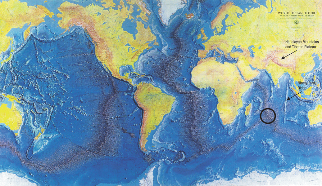
In the Indian Ocean, there is a point where plate tectonics theory would indicate that two or three spreading centers intersect, with one or three terminating.

How does plate tectonics theory explain this feature?

The Hydroplate theory says there are no spreading centers. Instead, it says the mid-ocean rises are gravity-induced features; the response to mass being removed caused the new ocean floor to spring upward all around the planet.

However, it seems impossible for the seafloor to be spreading away from this point to be able to create the feature while maintaining plate theories.
 
Last edited:

Stripe

Teenage Adaptive Ninja Turtle
LIFETIME MEMBER
Hall of Fame
"The Indian Plate is currently moving north-east at 5 centimetres (2.0 in) per year, while the Eurasian Plate is moving north at only 2 centimetres (0.79 in) per year. This is causing the Eurasian Plate to deform, and the Indian Plate to compress at a rate of 4 millimetres (0.16 in) per year." -- http://en.wikipedia.org/wiki/Indian_Plate

See also: Unusual Indian Ocean earthquakes hint at tectonic breakup

Neither of those sources are to do with the spot I indicated. :)
 

Stripe

Teenage Adaptive Ninja Turtle
LIFETIME MEMBER
Hall of Fame
Spoiler
hydroplateoverview-tharp_world_ocean_floor_map.jpg

Figure 43: World Ocean Floor. Notice the characteristic margins of each continent. Seaward from each ocean beach is a shallow, gradually sloping continental shelf, then a relatively steep drop, called the continental slope. This strange pattern is worldwide. Why? For a better look at the typical shape of this margin, see Figure 46 on page 115. Also notice the different characteristics of (1) continents and ocean basins, and (2) the Atlantic and Pacific Basins. Ninety East Ridge is so named because it lies almost exactly along 90°E longitude. Its straight, 3,000-mile length, and curious north-south orientation aimed at the Himalayas are important clues to past events on earth. (Note: As one moves toward polar regions on this type of map projection, east-west distances are stretched and do not reflect true distances.)

Why does the Mid-Oceanic Ridge intersects itself in the Indian Ocean (shown by the black circle)? Ask yourself how seafloor spreading could work there—moving away from that intersection point in four perpendicular directions. Answer: It can’t. As will be explained with many more examples in this and the next chapter, seafloor spreading is a myth. That alone falsifies plate tectonics. The hydroplate theory will provide a simple explanation for that intersection point and the Mid-Oceanic Ridge.


-source.​
 

User Name

Greatest poster ever
Banned
Neither of those sources are to do with the spot I indicated. :)

"The Rodrigues Triple Point (also, Rodrigues Triple Junction) is a geologic triple junction in the southern Indian Ocean where three tectonic plates meet: the African Plate, the Indo-Australian Plate, and the Antarctic Plate. The triple point is named for the island of Rodrigues which lies nearby." -- http://en.wikipedia.org/wiki/Rodrigues_Triple_Point
 

Stripe

Teenage Adaptive Ninja Turtle
LIFETIME MEMBER
Hall of Fame

Jonahdog

BANNED
Banned
Spoiler
hydroplateoverview-tharp_world_ocean_floor_map.jpg

Figure 43: World Ocean Floor. Notice the characteristic margins of each continent. Seaward from each ocean beach is a shallow, gradually sloping continental shelf, then a relatively steep drop, called the continental slope. This strange pattern is worldwide. Why? For a better look at the typical shape of this margin, see Figure 46 on page 115. Also notice the different characteristics of (1) continents and ocean basins, and (2) the Atlantic and Pacific Basins. Ninety East Ridge is so named because it lies almost exactly along 90°E longitude. Its straight, 3,000-mile length, and curious north-south orientation aimed at the Himalayas are important clues to past events on earth. (Note: As one moves toward polar regions on this type of map projection, east-west distances are stretched and do not reflect true distances.)

Why does the Mid-Oceanic Ridge intersects itself in the Indian Ocean (shown by the black circle)? Ask yourself how seafloor spreading could work there—moving away from that intersection point in four perpendicular directions. Answer: It can’t. As will be explained with many more examples in this and the next chapter, seafloor spreading is a myth. That alone falsifies plate tectonics. The hydroplate theory will provide a simple explanation for that intersection point and the Mid-Oceanic Ridge.


-source.​
What scientific journal is that from?
 

Stripe

Teenage Adaptive Ninja Turtle
LIFETIME MEMBER
Hall of Fame
The challenge is straightforward: Plate tectonics theory rides on the idea that hot, rising rock pushes plates away from each other at spreading centers. That means there must be rock rising at the Rodrigues Triple Point that is reaching near the surface and then pushing plates away from it in three directions.

This seems highly improbable.
 

User Name

Greatest poster ever
Banned
The challenge is straightforward: Plate tectonics theory rides on the idea that hot, rising rock pushes plates away from each other at spreading centers. That means there must be rock rising at the Rodrigues Triple Point that is reaching near the surface and then pushing plates away from it in three directions.

This seems highly improbable.

"The triple junction consists of two medium spreading ridges and one slow spreading ridge (the Southwest Indian Ridge). GLORIA sidescan sonar and French Sea Beam bathymetry data suggest that the two medium spreading ridges almost form one continuous ridge. Seafloor created by them is slowly rifted by the slow extension of the Southwest Indian Ridge, producing a progressively broadening and deepening rift." -- http://personalpages.manchester.ac.uk/staff/neil.mitchell/mor/mor.html
 

User Name

Greatest poster ever
Banned
The challenge is straightforward: Plate tectonics theory rides on the idea that hot, rising rock pushes plates away from each other at spreading centers. That means there must be rock rising at the Rodrigues Triple Point that is reaching near the surface and then pushing plates away from it in three directions.

This seems highly improbable.

"The Indian Ocean triple junction is a ridge-ridge-ridge type joining two medium-spreading ridges with one slow-spreading ridge. GLORIA long-range side scan sonar images show that, while the axial valleys of the two medium-spreading ridges are almost colinear, apart from a small ~5 km offset, the valley of the slow-spreading third axis does not meet the other two in a simple fashion. The axis of this slow-spreading Southwest Indian Ridge (SWIR), beyond the rift valley walls of the other two ridges, steadily deepens by over 1000 m away from the triple junction to reach 5000 m at 35 km. The GLORIA images show large normal faults around the deep SWIR rift valley, which increase in heave away from the triple junction and crosscut the abyssal hills formed at the faster-spreading Central Indian Ridge, indicating that extension across the SWIR is distributed over a zone 10 km or more wide. This zone also shows no evidence for the formation of new oceanic crust, suggesting that the extension may be amagmatic near the triple junction. The high relief of the SWIR rift flanks, containing tilted seafloor of the other two ridges, may be an isostatic response of the lithosphere to the deep valley produced by this rifting. These observations, which suggest the progressive development of a propagating SWIR rift by the extension of preexisting seafloor, may have general implications for the dynamics of oceanic spreading centers. In particular, the deepening and widening of the valley away from the triple junction is attributed to the competing effects of tectonic thinning and lithospheric cooling."

-- http://personalpages.manchester.ac.uk/staff/neil.mitchell/cv/iotj-dd.html
 

Stripe

Teenage Adaptive Ninja Turtle
LIFETIME MEMBER
Hall of Fame
"The Indian Ocean triple junction is a ridge-ridge-ridge type joining two medium-spreading ridges with one slow-spreading ridge. GLORIA long-range side scan sonar images show that, while the axial valleys of the two medium-spreading ridges are almost colinear, apart from a small ~5 km offset, the valley of the slow-spreading third axis does not meet the other two in a simple fashion. The axis of this slow-spreading Southwest Indian Ridge (SWIR), beyond the rift valley walls of the other two ridges, steadily deepens by over 1000 m away from the triple junction to reach 5000 m at 35 km. The GLORIA images show large normal faults around the deep SWIR rift valley, which increase in heave away from the triple junction and crosscut the abyssal hills formed at the faster-spreading Central Indian Ridge, indicating that extension across the SWIR is distributed over a zone 10 km or more wide. This zone also shows no evidence for the formation of new oceanic crust, suggesting that the extension may be amagmatic near the triple junction. The high relief of the SWIR rift flanks, containing tilted seafloor of the other two ridges, may be an isostatic response of the lithosphere to the deep valley produced by this rifting. These observations, which suggest the progressive development of a propagating SWIR rift by the extension of preexisting seafloor, may have general implications for the dynamics of oceanic spreading centers. In particular, the deepening and widening of the valley away from the triple junction is attributed to the competing effects of tectonic thinning and lithospheric cooling."

-- http://personalpages.manchester.ac.uk/staff/neil.mitchell/cv/iotj-dd.html

Can you explain any of this from the perspective of the proposed mechanism driving plate tectonic theory?
 

User Name

Greatest poster ever
Banned
Can you explain any of this from the perspective of the proposed mechanism driving plate tectonic theory?

Convection of magma:

doei_project_laurent_en1_30976.jpg
"Mantle (green) and melt (red and brown) trajectories predicted at the corner of two ridges, one spreading four times slower than the other. The blue surface is a particular level of the ridge pressure field, showing the relative strength of each spreading center. The slower ridge is able to tap into the stronger ridges' melting field although the melt trajectories are dispersed near the surface."

Source: http://www.whoi.edu/page.do?pid=97063&tid=3622&cid=16131
 

Jonahdog

BANNED
Banned
Stripe, what is your official stance on plate tectonics (in general) and the age of the earth ? -

His official stance on plate tectonics is to suggest you read Walt Brown's "hydro-plate theory". his official stance on the age of the earth is Bishop Ussher.

Both are just irrational but his thought process allows him to resort to emoticons and making fun of people with the knowledge that he is one of the favored ones and will never be banned. He consistently cherry picks bits of information and data and translates that to goddidit.

He is a hoot.
 

Stripe

Teenage Adaptive Ninja Turtle
LIFETIME MEMBER
Hall of Fame
Convection of magma:

"Mantle (green) and melt (red and brown) trajectories predicted at the corner of two ridges, one spreading four times slower than the other. The blue surface is a particular level of the ridge pressure field, showing the relative strength of each spreading center. The slower ridge is able to tap into the stronger ridges' melting field although the melt trajectories are dispersed near the surface."

Source: http://www.whoi.edu/page.do?pid=97063&tid=3622&cid=16131
Some questions:
What data or observations is this explanation based on?
The surface features are extremely detailed, with the triple point well defined even on Google Maps. How does mantle movement provide such detail? How can the available surface area of mantle on crust provide enough traction to form the surface features we see?
The surface feature we see at the triple point is unique. Why would that be?
 
Last edited:

User Name

Greatest poster ever
Banned
Along the western coast of Chile, three of Earth’s tectonic plates intersect in a way that does not occur anywhere else on the planet. Chile, and the other countries of South America, lie on top of the South American tectonic plate. To the west of Chile, the Nazca Plate extends beneath the Pacific Ocean and meets the Pacific Plate along a divergent plate boundary called the East Pacific Rise. The southern edge of the Nazca Plate adjoins the Antarctic Plate along another divergent plate boundary called the Chile Rise. The eastern edge of the Chile Rise is being subducted beneath the South American plate at the Chile Triple Junction (CTJ), which is unique because it consists of a mid-oceanic ridge being subducted under a continental tectonic plate:

eem_fig1-1_600.jpg

The eastern portion of the Nazca Plate is also being subducted along the Peru-Chile Trench, and the Andes mountains are one consequence of this process. Not surprisingly, complex movements of three tectonic plates at the CTJ result in numerous earthquakes. In fact, the largest earthquake ever recorded (magnitude 9.5) occurred along the Peru-Chile Trench in 1960.​

Source: http://oceanexplorer.noaa.gov/explorations/10chile/background/edu/media/whenplates.pdf
 

Stripe

Teenage Adaptive Ninja Turtle
LIFETIME MEMBER
Hall of Fame
Along the western coast of Chile, three of Earth’s tectonic plates intersect in a way that does not occur anywhere else on the planet. Chile, and the other countries of South America, lie on top of the South American tectonic plate. To the west of Chile, the Nazca Plate extends beneath the Pacific Ocean and meets the Pacific Plate along a divergent plate boundary called the East Pacific Rise. The southern edge of the Nazca Plate adjoins the Antarctic Plate along another divergent plate boundary called the Chile Rise. The eastern edge of the Chile Rise is being subducted beneath the South American plate at the Chile Triple Junction (CTJ), which is unique because it consists of a mid-oceanic ridge being subducted under a continental tectonic plate:


The eastern portion of the Nazca Plate is also being subducted along the Peru-Chile Trench, and the Andes mountains are one consequence of this process. Not surprisingly, complex movements of three tectonic plates at the CTJ result in numerous earthquakes. In fact, the largest earthquake ever recorded (magnitude 9.5) occurred along the Peru-Chile Trench in 1960.​

Source: http://oceanexplorer.noaa.gov/explorations/10chile/background/edu/media/whenplates.pdf
What I meant was: The surface feature we see at the triple point is unique.

It should have been obvious that I wasn't saying plate tectonics theory does not have other points where three plates meet.

For example, there are nine in your image, but none of them show a surface feature like what we see in the Indian Ocean. Why is that?
 

User Name

Greatest poster ever
Banned
Earth’s tectonic plates do not fracture along straight lines over a great distance because the Earth is not flat. With a flat surface, one force is pulling the paper 180° relative to the other force. Over a spherical surface, however, this tension extends radially in all directions...Under radial stress, the weak point extends along three branches, each pair forming an angle of ~120°. These branches converge at a central point known as a triple junction. So long as there is tension pulling away from the triple junction, each branch will rift in a more or less linear fashion. Therefore, the layout of Earth’s tectonic plates is characterized not so much by linear fractures at right angles, but rather by pseudo-hexagonal polygons...As tectonic plates pull away from one another, they typically create depressions in the Earth’s surface, due to a thinning of the crust. If this process occurs within a continent, the depression often forms a linear rift valley, where the anomalously thin crust results in low elevations and active volcanism...The East African Rift, which has been forming for at least 11 million years, provides one of the best examples of the continental branch of a triple junction. Given enough time, the depression may eventually subside below sea level, giving birth to a new ocean basin.

Once you understand how triple junctions form and how to recognize them, they appear everywhere on physiographic maps of the world. To this end, GoogleEarth is a great tool for exploring how Earth’s modern surface came to be. Look closely at mid-ocean ridges and continental edges: how many of them are characterized by ~120° angles that separate one plate from another or define valleys and ridges? Triple junctions thus explain the shape of familiar continents, like the west coast of Africa and its Brazilian counterpart, the west coast of South America, the Arabian peninsula and Red Sea, and even the Kara Sea and Yenisei river basin in western Siberia.​

Read more at the source: http://ageofrocks.org/2015/07/06/monday-minute-triple-junctions-and-the-age-of-the-earth/
 
Top